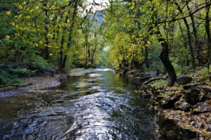
 The hydrographic artery of the Petrovac municipality is the
river Mlava. It is formed in the southeastern part of the
Žagubica valley from the islands of Žagubica wellhead and
Velika Tisnica. Mlava is one of the longest rivers in eastern
Serbia, with a total length of about 150 km. From it’s
formation to the confluence with the Danube near Kostolac,
the Mlava flows through the Žagubica valley, the Gornjak
gorge, the Mlava and Stig. The entire basin can be divided
into three parts: upper - Homolje, middle - Mlava and lower -
Stig. It kept the characteristics of the mountainous,
unpolluted river Mlava in the upper part of the basin, ie from
Žagubica to Petrovac.
The hydrographic artery of the Petrovac municipality is the
river Mlava. It is formed in the southeastern part of the
Žagubica valley from the islands of Žagubica wellhead and
Velika Tisnica. Mlava is one of the longest rivers in eastern
Serbia, with a total length of about 150 km. From it’s
formation to the confluence with the Danube near Kostolac,
the Mlava flows through the Žagubica valley, the Gornjak
gorge, the Mlava and Stig. The entire basin can be divided
into three parts: upper - Homolje, middle - Mlava and lower -
Stig. It kept the characteristics of the mountainous,
unpolluted river Mlava in the upper part of the basin, ie from
Žagubica to Petrovac.
One of the tributaries of the river Mlava in the municipality of Petrovac is the river Busur. Busur springs at the foot of the Gornjak mountains, and flows into Mlava near Petrovac. The river has a torrential character and during heavy rains it overflows it’s banks, flooding the surrounding terrains, causing great damage to crops. An artificial lake, with an area of about 18 ha, was formed in the 1960s in the area of the village of Busur (named after this river). Water flows through every settlement in the Petrovac municipality, along which in most cases the villages were named, the largest of which is Vitovnica. All of them mostly flow into the Mlava and those that flow to it from the right side have the character of mountain streams. Thanks to the relief characteristics, the municipality is rich in springs, many of which have healing properties and to which many pagan customs of this region are connected.